https://wattsupwiththat.com/2021/12/09/rain-caused-volcano-to-erupt-because-climate-change/
by David Middleton
Hat tip to Ted…
Message: Please find a qualified geologist to take on this nonsense.
They cite “the conversation” as their authority.
https://thehill.com/policy/equilibrium-sustainability/584770-equilibrium-sustainability
Today is Tuesday. Welcome to Equilibrium, a newsletter that tracks the growing global battle over the future of sustainability. Subscribe here: thehill.com/newsletter-signup.Thunderous rains were responsible for the deadly eruption that killed at least 22 people near Indonesia’s Mount Semeru over the weekend, nonprofit journalism site The Conversation reported.
The rain collapsed the stony “lava dome” that plugged the peak of the already rumbling volcano, with effects similar to shaking up a fizzy drink and removing the cap, according to The Conversation.
The fatal eruption also damaged 3,000 buildings, while blanketing some villages in up to 13 feet (4 meters) of volcanic debris — a disaster that highlights the risk to the roughly 1 billion people worldwide who live within 60 miles of an active volcano.
WUWT Tip submission
WTF does a volcanic eruption have to do with sustainability? Volcanic soils are often extremely fertile… Think coffee. Living near a volcano is a dicey proposition… Always has been, always will be. While they didn’t expressly blame this on climate change, it’s pretty clear that the context (“Equilibrium, a newsletter that tracks the growing global battle over the future of sustainability”) is climate change and/or anti-capitalism.
When I read the article on The Hill website, the first thing that came to mind was the Telephone Game.
How to Play the Telephone Game
Co-authored by wikiHow Staff
Last Updated: September 16, 2021The game of telephone is a classic ice breaker and party game. It’s easy to set up and a lot of fun to play. You and your friends will try to pick a word or phrase, “pass it on” by whispering it to someone next to you, and have fun seeing how much it changed during the game. All you will need to play is a couple of friends, a word or phrase, and a quiet whisper.
According to The Hill authors, Sharon Udasin (BA in French & English, MS in Journalism) and Saul Elbein (unspecified degree in Humanities & Journalism), “thunderous rains were responsible for the deadly eruption.”
Phys.org republished The Conversation article…
DECEMBER 7, 2021
Mount Semeru’s deadly eruption was triggered by rain and storms, making it much harder to predict
by Heather Handley, The ConversationThe eruption of Mount Semeru in Indonesia on Saturday tragically claimed the lives of 22 people, with another 22 still missing and 56 injured. More than 5,000 people have been affected by the eruption, and more than 2,000 people have taken refuge at 19 evacuation points.
[…]
Mt Semeru is one of the most active volcanoes in Java, with activity taking place in 74 of the past 80 years. The volcano’s current eruptive phase began in 2014, with frequent emissions of ash plumes to hundreds of meters above the crater, pyroclastic flows and glowing lava avalanches.
Unexpected larger-scale eruption
But Saturday’s eruption was, unexpectedly, much larger than the ongoing background of activity. The Head of the Geological Agency of the Ministry of Energy and Mineral Resources, Eko Budi Lelono, said a thunderstorm and persistent rain had eroded part of the volcano’s lava dome—a “plug” of solidified lava at the summit. This caused the dome to collapse, triggering the eruption.
[…]
According to Heather Handley (PhD in Volcano Geochemistry), “a thunderstorm and persistent rain had eroded part of the volcano’s lava dome… This caused the dome to collapse, triggering the eruption” of “one of the most active volcanoes in Java, with activity taking place in 74 of the past 80 years.”
While “triggering” might not be the most accurate word to use here, the collapse of lava domes quite frequently precedes eruptions of active volcanoes, as Ms. Handley goes on to discuss…
Lava dome collapse is a common trigger of volcanic eruptions, and has been behind some of the deadliest eruptions in history. Collapse of the unstable dome of solidified lava is rather like taking the top off a fizzy drink bottle, depressurising the system and triggering an eruption. Lava domes sometimes collapse under their own weight as they grow, or they can be weakened by external weather conditions, as was evidently the case at Mt Semeru.
This is from Smithsonian Institution’s Global Volcanism Program:
Semeru
Indonesia
8.108°S, 112.922°E; summit elev. 3657 m
All times are local (unless otherwise noted)
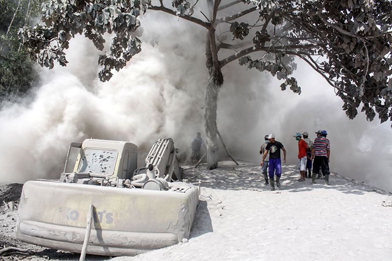
PMVBG reported collapses of the lava dome in Semeru’s Jonggring Seloko Crater and SE-flank flow during 1-6 December. On 1 December material collapsed from the unstable distal end of a 1-km-long lava flow in the SE-flank Kobokan drainage, sending a pyroclastic flow 700 m down the valley. Subsequent avalanches were recorded by the seismic network that day and on 3 December were not visually confirmed, likely due to several days of rainy conditions. At 1330 on 4 December the seismic network recorded avalanche signals. A larger collapse began at 1447 was seen by an observer at the Mount Semeru Volcano Observation Post and identified in data collected by PVMBG. Avalanches of incandescent material from the summit dome and SE-flank lava flow descended 500-800 m. Pyroclastic flows were visible at 1510 descending the Kobokan drainage and a sulfur odor was noted. At 1520 a large pyroclastic flow produced a large roiling and expanding ash cloud that eventually rose to 15 km (50,000 ft) a.s.l. Reports from residents described darkness from airborne ash and rainy/foggy conditions. Pyroclastic material was deposited in two districts in the Lumajang regency, and eight districts in the neighboring Malang regency were covered with ash. Preliminary estimates suggested that deposits extended at least 16 km SE from the summit.
According to the Darwin VAAC satellite observations acquired at 1630 showed a detached ash cloud drifting SW at an altitude of 15 km (50,000 ft) a.s.l. At 1740 the ash cloud continued to drift SW and a second ash cloud was drifting W at 9.1 km (30,000 ft) a.s.l. The second ash cloud had detached by 1840. On 5 December satellite images showed the two ash clouds still drifting SW and W, and possible diffuse ash emissions rising to 4.6 km (15,000 ft) a.s.l.; ash had dissipated by 1000.
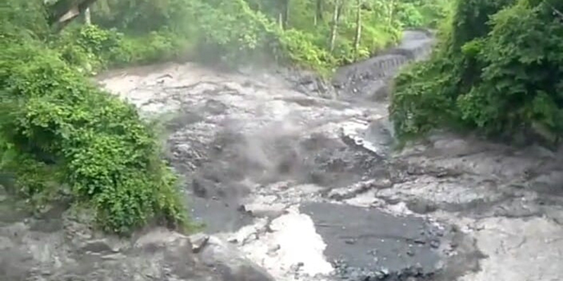
Following the 4 December pyroclastic flow Badan Penanggulangan Bencana Daerah (BPBD) issued a warning to residents to stay away from drainages due to lahar hazards and began evacuating people in high-risk areas. Ten people trapped in a building could not be reached because of scalding hot deposits but were later rescued. Almost all of the houses in the Curah Kobokan area had been destroyed, mainly by pyroclastic flows, though some residents reported roof collapses from ashfall. One area of Curah Kobokan was inundated by hot lahars that took down trees. Pyroclastic flows also destroyed the Gladak Perak bridge, 13 km SE of the summit, which linked residents of Pronojiwo and Lumajang; the national road leading to Malang was blocked by tephra and fallen trees. According to news articles and BNPB, by the next day 14 people were confirmed to have died, 57 had been injured and taken to hospitals (more than a dozen of were in critical condition due to severe burns), and at least seven residents and sand miners working along the river in Curah Kobokan were missing. About 1,300 people had relocated to evacuation centers or alternative housing.
Additional pyroclastic flows during 5-6 December descended 2-3 km SE, and incandescent avalanches descended 500 m. At 0855 on 6 December a pyroclastic flow traveled 4 km down the SE drainage, temporarily halting rescue and recovery efforts. Later that day, the head of BNPB, police officers, and others conducted a 15-minute overflight of Curah Kobokan and observed steam plumes rising from the deposits. Initial estimates were that 2,970 houses and 38 educational facilities across several sub-districts in Lumajang Regency had been destroyed or damaged by the pyroclastic flows. Authorities also traveled to the fallen bridge and other nearby locations, noting damaged vegetation, fallen trees, and volcanic deposits up to 30 cm thick along the road.
By 7 December an estimated 4,250 residents were displaced in about 20 evacuation centers; most people originating from the Lumajang Regency and fewer from the Malang and Blitar regencies. The number of fatalities reached 34, with another 22 people missing. Search efforts focused on the villages of Renteng, Sumberwuluh, and Kobokan Curah, but daily afternoon rains hampered rescue and recovery efforts.
Geological Summary. Semeru, the highest volcano on Java, and one of its most active, lies at the southern end of a volcanic massif extending north to the Tengger caldera. The steep-sided volcano, also referred to as Mahameru (Great Mountain), rises above coastal plains to the south. Gunung Semeru was constructed south of the overlapping Ajek-ajek and Jambangan calderas. A line of lake-filled maars was constructed along a N-S trend cutting through the summit, and cinder cones and lava domes occupy the eastern and NE flanks. Summit topography is complicated by the shifting of craters from NW to SE. Frequent 19th and 20th century eruptions were dominated by small-to-moderate explosions from the summit crater, with occasional lava flows and larger explosive eruptions accompanied by pyroclastic flows that have reached the lower flanks of the volcano.
Sources: Pusat Vulkanologi dan Mitigasi Bencana Geologi (PVMBG, also known as CVGHM), Badan Nacional Penanggulangan Bencana (BNPB), National Public Radio (NPR), BBC News, Earth Observatory of Singapore, Remote Sensing Lab
Global Volcanism Program, 2021. Report on Semeru (Indonesia). In: Sennert, S K (ed.), Weekly Volcanic Activity Report, 1 December-7 December 2021. Smithsonian Institution and US Geological Survey.
We’ve gone from “thunderous rain” suddenly causing the eruption of an otherwise peaceful volcano to one of the most active volcanoes, in a very volcanically active area, in a place where it rains a lot, erupting after several days of heavy rain.
This is what the mostly peaceful volcano was doing a year ago…
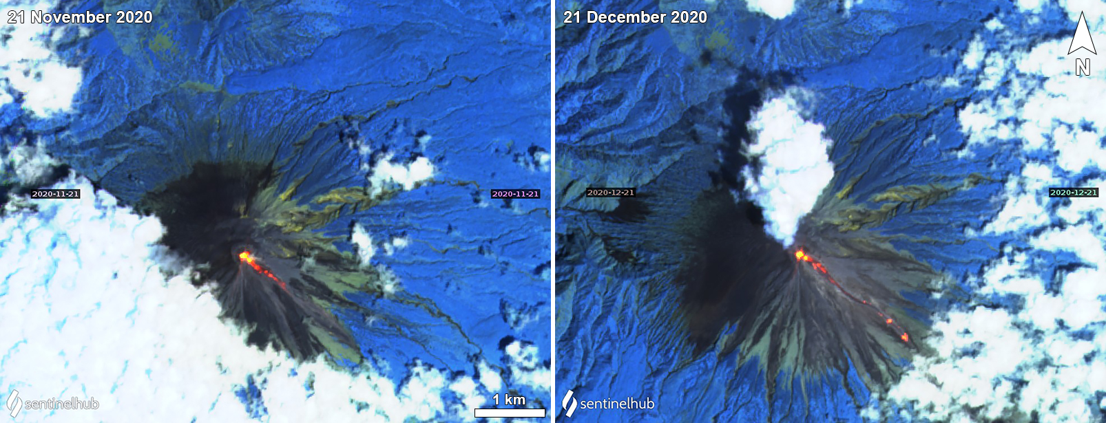
https://volcano.si.edu/volcano.cfm?vn=263300
https://volcano.si.edu/volcano.cfm?vn=263300

https://volcano.si.edu/volcano.cfm?vn=263300
“Thunderous rains were [NOT] responsible for the deadly eruption.”
On 1 December material collapsed from the unstable distal end of a 1-km-long lava flow in the SE-flank Kobokan drainage, sending a pyroclastic flow 700 m down the valley. Subsequent avalanches were recorded by the seismic network that day and on 3 December were not visually confirmed, likely due to several days of rainy conditions. At 1330 on 4 December the seismic network recorded avalanche signals. A larger collapse began at 1447 was seen by an observer at the Mount Semeru Volcano Observation Post and identified in data collected by PVMBG. Avalanches of incandescent material from the summit dome and SE-flank lava flow descended 500-800 m.
Global Volcanism Program, 2021. Report on Semeru (Indonesia). In: Sennert, S K (ed.), Weekly Volcanic Activity Report, 1 December-7 December 2021. Smithsonian Institution and US Geological Survey.
Rain and the erosion caused by runoff played a role in the collapse of an unstable lava dome, releasing a pyroclastic flow from an extremely active volcano that was already erupting.

References
Global Volcanism Program, 2021. Report on Semeru (Indonesia) (Bennis, K.L., and Venzke, E., eds.). Bulletin of the Global Volcanism Network, 46:4. Smithsonian Institution. https://doi.org/10.5479/si.GVP.BGVN202104-263300
Global Volcanism Program, 2021. Report on Semeru (Indonesia). In: Sennert, S K (ed.), Weekly Volcanic Activity Report, 1 December-7 December 2021. Smithsonian Institution and US Geological Survey.
Global Volcanism Program, 2013. Volcanoes of the World, v. 4.10.3 (15 Oct 2021). Venzke, E (ed.). Smithsonian Institution. Downloaded 09 Dec 2021. https://doi.org/10.5479/si.GVP.VOTW4-2013.
Global Volcanism Program, 2013. Semeru (263300) in Volcanoes of the World, v. 4.10.3 (15 Oct 2021). Venzke, E (ed.). Smithsonian Institution. Downloaded 09 Dec 2021 (https://volcano.si.edu/volcano.cfm?vn=263300). https://doi.org/10.5479/si.GVP.VOTW4-2013