
https://electroverse.net/arctic-conditions-grip-the-united-states/
Following the three historic snowstorms which buried parts of the U.S. last month, sub-zero temperatures are now blasting hundreds of millions of Americans. Winter has arrived early, as predicted by low solar activity, and a meridional (wavy) jet stream flow.
Lows throughout the week will be more like January temperatures — readings below zero are forecast for many U.S. states, and temps down into the teens are even forecast as far south as Texas.
Some Eastern could experience temperature departures some 30F below the seasonal average on Wednesday afternoon, according to CNN meteorologist Taylor Ward.
While freeze watches and warnings also extend as far south as Florida.
 Florida Storms@FloridaStorms
For Tuesday Night: A Freeze Warning has already been issued for the #Pensacola area; Freeze Watch farther east. #FLwx

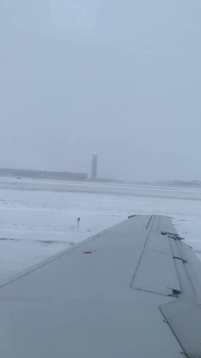
The Arctic conditions are already having an impact on transportation.
Harsh weather cancelled more than 1,300 flights at Chicago airports alone on Monday, with snow and ice causing chaos on the runways — this Twitter video shows an American Airlines plane sliding off the runway while landing at O’Hare Int. Airport on Monday morning:
 Andrea Blanford@AndreaABC11
BREAKING: @AmericanAir Flight AA4125 from @flyfrompti to @fly2ohare slides off runway in Chicago this morning. Passengers tell me everyone is OK, deplaned and on buses to terminal. Video: Joseph Lian from Greensboro. @ABC11_WTVD @ABC #ABC11
The National Weather Service (NWS) has warned that “widespread record cold” will engulf much of the country this week, bringing the possibility of 385 new cold records from the Plains to the East Coast through Thursday (make that more like 3,000 — but we’ll be reporting on them as they come in).
“The Arctic air mass that has settled across much of the northern and central U.S. will continue to push south and eastward,” said the NWS, “spreading the much below average temperatures into the Southeast and East on Tuesday and continuing into Wednesday.”
NWS meteorologist Kevin Birk said Illinois, Wisconsin and Iowa could all see temperatures plummet to the single digits — and that Chicago’s forecast high of 21F “would be a full seven degrees lower than the previous record set for November 12.”
Birk added, “This is an air mass that’s more typical for the middle of January than mid-November. It is pretty much about the coldest we can be this time of year — it could break records all over the region.”
 NWS Eastern Region
✔@NWSEastern
Arctic air will move in behind the upcoming storm, bringing some very cold temperatures, especially for mid-November, to the eastern US for the middle of the upcoming week.


And then there’s the snow.
More than 70 million people could see accumulating snow from Colorado to Maine, with Winter warnings or advisories stretch from the Midwest to New England.
At least four deaths have been linked to the snow thus far — multiple car crashes on Monday were caused by snowfall, ice and poor driving conditions, officials said.
 Ryan
Ryan✔@RyanMaue
Here comes the “Arctic blast”
Over the next 4-days, abnormally cold air (record cold) will descend upon the Lower 48 thru Texas to the Gulf Coast.The “coldest” actual temperatures will be over the Great Lakes leading to heavy “Lake Effect” snow.

Don’t buy into any bogus political ideologies.
No, record cold & snow IS NOT made “more likely in a warming world”. In fact, the IPCC’s line –until not that long ago– was that “milder winter temperatures will decrease heavy snowstorms”.
These overpaid, peer-reviewed scientists got it spectacularly wrong, and only very recently have some of them actually changed their tune. Now, according to these frauds, EVERYTHING IS THE RESULT OF AGW.
–an illogical, agenda-driven theory, and one easily debunked by real-world observations.
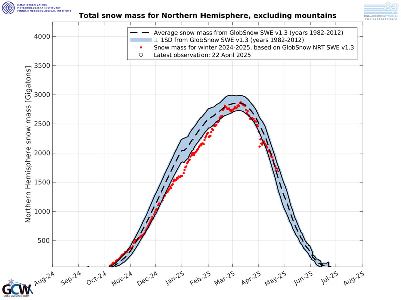
Observations such as the Total Snow Mass in the Northern Hemisphere growing exponentially over the past few years, correlating neatly with low solar activity. This FACT alone should give alarmist cause for doubt — this astonishing level of snow cover simply isn’t possible in a warming world. And the data is there for all to access; unambiguous, unadjusted, and requiring no over-complicated scientific explanation. Put simply, there is currently a shit-ton of snow covering the Northern Hemisphere:

Again, this level of snow cover IS NOT possible with global warming, it comes with global cooling. And albedo is now exasperating its effect — a phenomenon we’re actually seeing this week, as Arctic air is kept cold as it sinks south over a snow-covered Canada and Midwest U.S..
This is how glaciers form.
This is how ice ages begin — including little ones like the Maunder Minimum:

The lower-latitudes are refreezing in line with historically low solar activity.
NASA has revealed this upcoming solar cycle (25) will be “the weakest of the past 200 years,” and they’ve correlated previous solar shutdowns to prolonged periods of global cooling here.


Prepare for the COLD — grow your own.
Social Media channels are restricting Electroverse’s reach — be sure to subscribe to receive new post notifications by email (the box is located in the sidebar >>> or scroll down if on mobile).
And/or become a Patron by clicking here: patreon.com/join/electroverse
Any way you can, help us spread the message so others can survive and thrive in the coming times.
Grand Solar Minimum + Pole Shift
