By Meteorologist Paul Dorian – Arcfield – arcfieldweather.com

8:00 AM | *A recap of 2022 and the news is generally good…Atlantic Basin and Northern Hemisphere tropical activity below-normal…US tornadoes below-normal…a quieter year in California for wildfires*
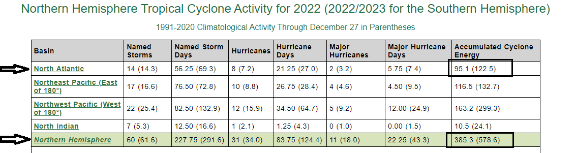
The Accumulated Cyclone Energy (ACE) is the best measure of overall tropical activity as it factors in both longevity and magnitude for individual systems. The ACE for the 2022 tropical season was below-normal across the Atlantic Basin (upper right box) and for the entire Northern Hemisphere (lower right box). Data courtesy Colorado State University, NOAA (climatological averages are shown in parentheses to the right of observed values for given location)
Overview
Despite the fact that the state of Florida suffered through direct impact by two hurricanes in just a six-week time period, the Atlantic Basin as a whole featured below-normal tropical activity in 2022 as measured by a metric known as the Accumulated Cyclone Energy (ACE). In addition, the entire Northern Hemisphere experienced below-normal tropical activity this year and – as was the case last year – the quieter-than-normal Pacific Ocean led the way to those favorable hemisphere-wide results. In terms of tornadoes, more good news in 2022 as it has been another below-normal year in the US and, once again, there were no EF-5’s observed (i.e., most powerful type of tornado). Finally, with respect to wildfires, it was a quieter year in California than the past few with some well-timed rainfall. The trend in the number of wildfires across the entire US continues to be downward for the past 15 years despite an uptick nationwide in 2022.

Colder-than-normal sea surface temperatures continue to dominate the scene in the equatorial part of the Pacific Ocean in much the same way as in the prior two years. These “La Nina” conditions likely played an important role in the below-normal tropical activity across parts of the Pacific Ocean which has a huge impact on the Northern Hemisphere as a whole. Map courtesy NOAA, tropicaltidbits.com (as of 27 Dec 2022)
Atlantic Basin and Northern Hemisphere tropical activity…below-normal
The state of Florida suffered through an active tropical season in 2022 being directly impacted by two hurricanes, Ian and Nicole, in just a six-week time period. However, in the Atlantic Basin as a whole which includes the Atlantic Ocean, Gulf of Mexico and Caribbean Sea, the 2022 tropical season was below-normal in overall activity. In addition, the Pacific Ocean – the world’s largest and deepest by far – experienced below-normal tropical activity in 2022 which contributed greatly to overall below-normal levels for the entire Northern Hemisphere.
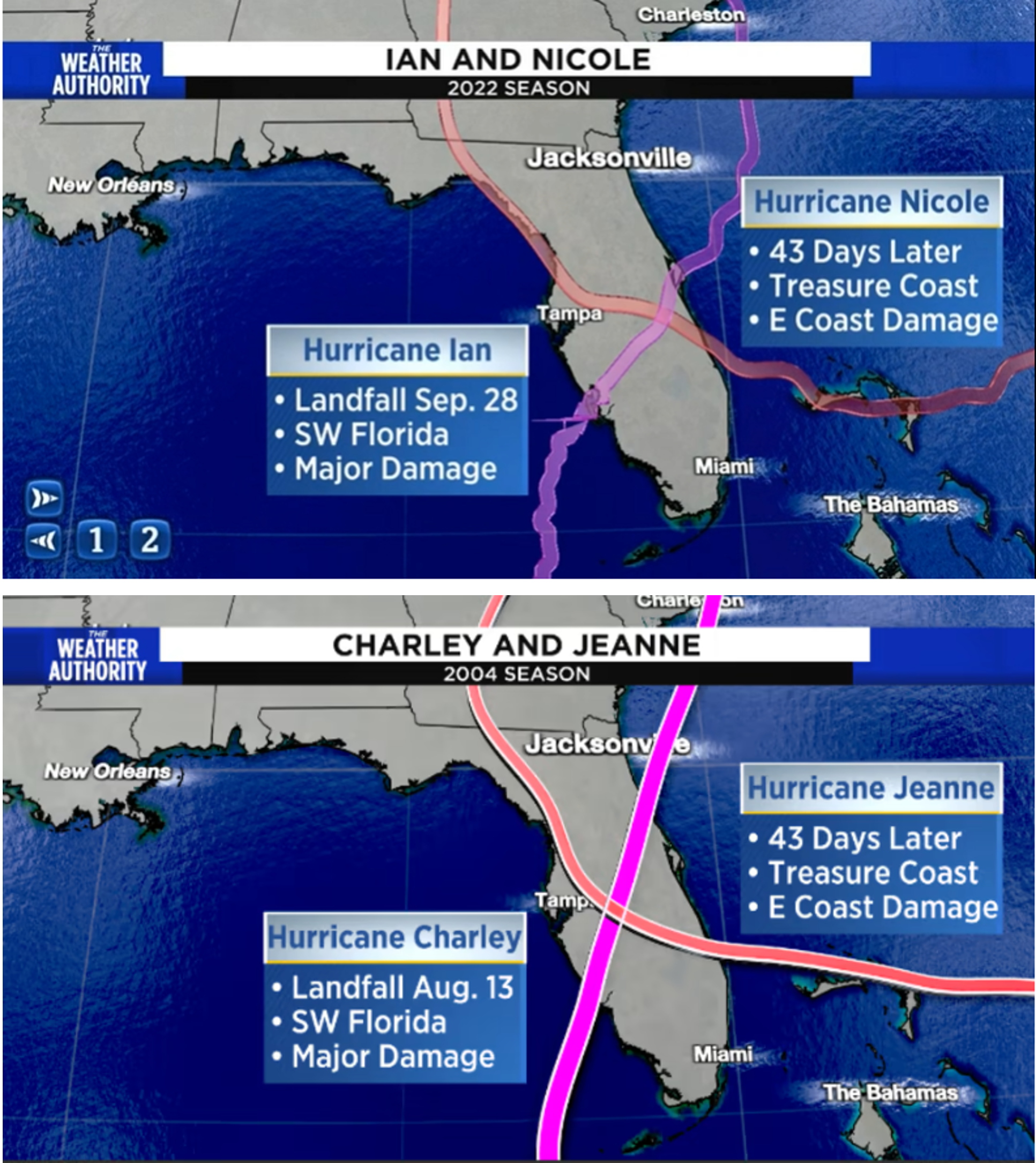
While the Atlantic Basin experienced below-normal Accumulated Cyclone Energy (ACE) for the 2022 tropical season, the state of Florida had to deal with two direct hits by hurricanes in a six-week time period. Hurricane Ian made landfall as a “major” category 4 storm on September 28th doing serious damage to southwestern Florida and Hurricane Nicole impacted the state 43 days later. In an odd twist, a very similar sequence of events took place in 2004 with Hurricanes Charley and Jeanne with similar “cross-paths” and exactly the same 43 days apart. Plots courtesy “News4jax.com” (David Heckard, Jacksonville, FL)
The “below-normal” attribution for the Atlantic Basin, Pacific Ocean and the Northern Hemisphere as a whole comes by using a metric known as the Accumulated Cyclone Energy (ACE). The ACE metric – which was originally created by Dr. William Gray and associates at Colorado State University and later tweaked by NOAA – not only factors in the intensity of a tropical cyclone, it also takes into account its longevity. A “major” hurricane, for example, that lasts for a long time will have a much bigger impact on the accumulated cyclone energy than a short-lived and weaker tropical system. The ACE levels for 2022 were below-normal in the Atlantic Ocean, both sectors of the Pacific Ocean (i.e., east and west of the international date line), and also in the Indian Ocean leading to below-normal levels for the entire Northern Hemisphere.

Global Hurricane Frequency (top), Accumulated Cyclone Energy (bottom) have trended relatively flat since 1980. (Data/plots courtesy Colorado State University, Chris Martz (Twitter))
The below-normal activity in the Atlantic Basin this year was fueled at least in part by persistent higher levels of wind shear in the main breeding grounds region of the tropical Atlantic Ocean which is somewhat unusual for a year with La Nina conditions in the equatorial part of the Pacific Ocean. Typically, colder-than-normal sea surface temperatures in the tropical Pacific Ocean (i.e., La Nina conditions) lead to reduced overall wind shear in the tropical Atlantic Ocean and this, in turn, usually contributes to a more active tropical season in the Atlantic Basin. In the Pacific Ocean, the results in 2022 were more predictable as La Nina conditions usually act to suppress tropical activity and indeed, both sectors of the world’s largest ocean (i.e., to the east and west of the international date line) experienced below-normal levels.

Of all the countries around the world, the US has the highest number of tornadoes and the totals this year (black line) fall quite low on the “percentile ranking” scale – just below the lowest 25th percentile (blue line) as determined by NOAA’s Storm Prediction Center. (Plot courtesy NOAA (Harold Brooks NSSL, Greg Carbin NOAA SPC), data through 12/26)).
US tornadic activity…below-normal
2022 has been a below-normal year in terms of the number of tornadoes across the nation ranking just below the “25th percentile” in a ranking of annual trends. The United States has the most tornadoes of any country, as well as the strongest and most violent tornadoes. According to data from NOAA’s Storm Prediction Center (SPC), the long-term trend of US tornado frequency has been relatively flat since the 1950’s.

The long-term trend in US tornado frequency has been relatively flat since 1954 as seen on this plot produced using data from NOAA’s Storm Prediction Center. (Courtesy NOAA, Chris Martz (Twitter))
More good news from this year with respect to tornadoes is that – once again – there were no observed tornadoes classified as “EF-5” which is the classification given to the most powerful type of all. In fact, it has now been more than 8 years since the last “EF-5” tornado struck in the US (Moore County, Oklahoma during May of 2013). According to NOAA, there have been a total of 36 “EF-5” tornadoes in the US since 1970 with 14 of those occurring in the 1970s.
Here is a summary of the details on 2022 tornadoes in the state of Pennsylvania:
– 8 total tornadoes on 3 separate days
– 9 counties impacted
– 3 EF0, 3 EF1, and 2 EF2
– 2nd most March tornadoes in PA behind only 1976 (8)
– 1st year since 1972 with no tornadoes in PA during June and July
[One final note, the current weather pattern across the nation is very active with numerous storms to pound California and other parts of the western US. One of these Pacific Ocean systems will push eastward into the Mississippi Valley region by the early and middle parts of next week and it very well may contribute to a severe weather outbreak – possibly to even include isolated tornadoes…something to monitor in coming days].

A quieter year in California for wildfires…Number of US wildfires continues on a 15-year downward trend
Overall, it was a somewhat quieter year in 2022 for the state of California with respect to wildfire activity at least compared to the past few. While this year saw more than 362,000 acres burned in the Golden State, it was the fewest since 2019 and – to put it into perspective – last year’s acreage of 2.5 million was about seven times larger. And these last two years paled in comparison to the record-breaking year of 2020, when more than 4.3 million acres were ablaze in California. Almost a quarter of the acres burned this wildfire season in California took place in El Dorado and Pacer Counties during the “Mosquito Fire” in September and October.

The nation as a whole experienced nearly normal temperatures in 2022 at +0.133 degrees (F) and California had some coastal spots slightly below-normal and some interior locations slightly above-normal. Map courtesy NOAA, Weather Bell Analytics
Although California endured another drought year in 2022, much of the state was spared the worst of the dryness during the wildfire season and, in some cases, well-timed rainfall came to the rescue (Credit for California wildfire information: “calmatters.org”, California State Emergency Services Department). [Note: Drought conditions will actually be alleviated significantly across California during the next couple of weeks with excessive rainfall amounts in a very active weather pattern and also some incredible higher-elevation snows (e.g., Sierra Nevada)]. Temperatures averaged pretty close to normal for 2022 across the nation and also across California with some coastal spots ending up a bit below-normal and some inland locations a bit above normal. Across the nation in 2022, there was an uptick in the “total number of wildfires” despite the reduced numbers this year in California. The overall trend across the nation, however, continues on a slightly downward track since 2008 as reported by the National Interagency Fire Center (NIFC).
Meteorologist Paul Dorian
Arcfield
arcfieldweather.com