
Is Recent Record Cold Just La Niña, or the Onset of Global Cooling?
By Physicist Dr. Ralph Alexander
Little noticed by the mainstream media in their obsession with global warming is an exceptionally chilly 2020-21 winter in the Northern Hemisphere and an unusually early start to the Southern Hemisphere winter. Low temperature and snowfall records are tumbling all over the globe. The harsh cold has already crippled this year’s crops and vines in Europe, while the U.S. state of Texas was ravaged by the subfreezing polar vortex.
Is this the beginning of the predicted grand solar minimum, which was the subject of an earlier post – or simply a manifestation of the naturally occurring La Niña cycle? A grand solar minimum is signified by a steep decline in the maximum number of sunspots during the 11-year solar cycle – a decline that appears to be underway already.
The familiar El Niño and La Niña cycles arise from seesaw changes in surface temperatures in the tropical Pacific Ocean and last for periods of a year or more at a time. The persistent but irregular pattern is visible in the graph below, showing satellite measurements of the global temperature since 1979. Warm spikes such as those in 1998, 2010 and 2016 are due to El Niño; cool spikes like those in 2000 and 2008 are due to La Niña. The climatic effects of El Niño and La Niña include catastrophic flooding in the western Americas and flooding or severe drought in Australia; La Niña has also been tied to major landfalling hurricanes in both the U.S. and the western Pacific.

The zero baseline in the figure represents the average temperature in the tropical lower atmosphere or troposphere from 1991 to 2020 (though the satellite record began in 1979). Observations in the troposphere are a more reliable indicator of global warming than surface data, which are distorted by the urban heat island effect on land and by insufficient measurement stations across the oceans.
Right now, in May 2021, it’s clear that we’re experiencing another La Niña, with the mean April temperature having fallen back to the long-term average. This isn’t permanent of course, and the mercury will continue to rise and fall with future El Niño and La Niña fluctuations. But those fluctuations are superimposed on an overall warming trend of 0.14 degrees Celsius (0.25 degrees Fahrenheit) per decade at present – the familiar global warming.
Whether the present frigid and snowy conditions in much of the world are merely a result of La Niña, or the start of a longer cooling trend, we won’t know for several years yet. Climate, after all, is a long-term average of the weather over an extended period of time, up to decades.
Nonetheless, there’s ample evidence that the current cold snap is not about to let up. At the same time as the UK experienced its lowest average minimum temperature for April since 1922, and both Switzerland and Slovenia suffered record low temperatures for the month, bone-chilling cold struck Australia, New Zealand and even normally shivery Antarctica in the Southern Hemisphere. The next figure shows how the 2021 sea ice extent (in blue) around Antarctica is above or close to the 30-year average from 1981 to 2010 (in gray).

Snow records have continued to be broken around the world too. Belgrade, the capital of Serbia, registered its all-time high snowfall for April, in record books dating back to 1888; during April, both Finland and Russia reported their heaviest snow in decades; and the UK, Spain and several countries in the Middle East saw rare spring snowfalls from March to May. On the other side of the globe, up to 22 cm (9 inches) of snow fell on southeastern Australia mountain peaks a full two months before the start of the 2021 ski season; and southern Africa was also blanketed in early-season snow.
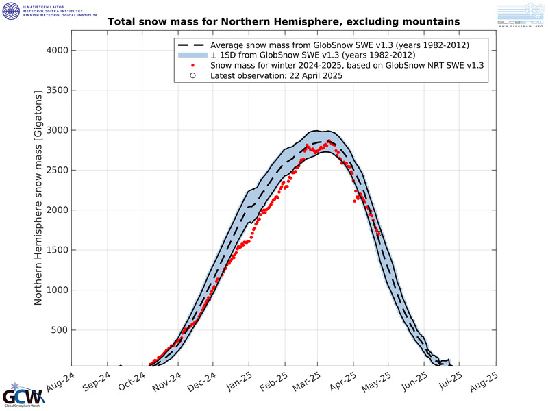
The figure below shows the Northern Hemisphere snow mass (excluding mountains) for the current season, based on data from the Finnish Meteorological Institute. As can be seen, the snow mass for much of the season has tracked more than one standard deviation above the average for 1982-2012, and in March 2021 exceeded the average by two standard deviations. The mass is measured in billions of tonnes (Gigatonnes, Gt where 1 tonne = 1.102 U.S. tons).

As startling as all this unusual weather is, it should be noted that recent bursts of extreme cold have sometimes been interspersed with brief periods of unseasonal warmth. Such swings between extremes may result from jet stream blocking, a phenomenon that can arise from natural sources such as a downturn in UV from a quieter sun, which can in turn produce changes in upper atmosphere wind patterns.
