
By Meteorologist Paul Dorian
Vencore, Inc. – vencoreweather.com
Overview
Whether you’re talking about major (category 3, 4 or 5) hurricanes or tornadoes, there is good news this year for the US in that – similar to most recent years – these extreme weather-related events are down across the nation compared-to-normal. In fact, in the case of tornadoes, we are on pace for one of the quietest years in the last decade and with respect to land falling major hurricanes in the US, an unprecedented streak in the record-keeping era continues through yet another tropical season.
Hurricanes
In our springtime “Tropical Outlook”, Vencore Weather indicated it would likely be an above-normal tropical season in the Atlantic Basin which includes the tropical Atlantic Ocean, Caribbean Sea, and Gulf of Mexico with 14 named storms, 7 hurricanes and 3 major hurricanes. As it stands now, the Atlantic Basin saw 15 named storms during 2016, including 7 hurricanes (Alex, Earl, Gaston, Hermine, Matthew, Nicole, and Otto), 3 of which were major hurricanes (Gaston, Matthew and Nicole) in the first above-normal season since 2012. A major factor in that above-normal outlook was the anticipated demise of El Nino in the tropical Pacific Ocean which peaked late in 2015. El Nino (warmer-than-normal water) actually has an inhibiting effect on tropical activity in the Atlantic Basin as it tends to increase wind shear in that region. Five named storms made landfall in the United States during 2016, the most since 2008 when six storms struck; however, none of these were of major hurricane status. Tropical Storms Colin and Julia, and Hurricane Hermine made landfall in Florida. Tropical Storm Bonnie and Hurricane Matthew struck South Carolina. The strongest and longest-lived storm of the season was Matthew, which reached maximum sustained surface winds of 160 miles per hour and lasted as a major hurricane for eight days from Sept. 30 to Oct. 7. In fact, Matthew was the first category 5 hurricane in the Atlantic basin since Felix in 2007.
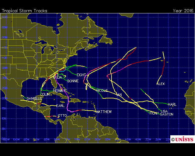
Storm tracks in the Atlantic Basin during the 2016 tropical season; map courtesy Unisys
Much of this year’s tropical activity in the Atlantic Basin stayed out over the Atlantic Ocean sparing the US with any landfalling major hurricanes. In fact, this major hurricane drought in the US continues an unprecedented streak in the record-keeping era which began in the middle 1800’s. The last major hurricane to strike the US mainland was Hurricane Wilma of late October 2005 which was a record-breaking year for tropical activity. Furthermore, this year continues a downtrend in hurricanes of any intensity for the US mainland. The number of hurricane landfalls in the US of any intensity over the last eight years is four and that is the lowest on record (highest in an 8-year period is 22 (1916); source Dr. Roger Pielke, Jr.
One streak that did end this year in the US was another unprecedented streak in which the state of Florida had not been hit by a hurricane of any intensity until Hurricane Hermine came ashore in early September as a category 1 storm. By the way, just as a point of comparison, in 1954 the US was hit by 3 major hurricanes in less than 10 weeks.

Blue bar at far right represents the record-breaking number of days in the US without any major hurricane landfalls (Note-the streak is projected out to the beginning of the next hurricane season which officially will begin on June 1, 2017); source Dr. Roger Pielke, Jr.
One of the best ways to measure tropical activity is with “accumulated cyclone energy” (ACE) which takes into account both the strength and longevity of tropical systems. ACE is a commonly-used metric for assessing tropical activity because it is not dependent on exact numbers of named storms or hurricanes, but rather is based on both the intensity and longevity of all tropical storms and hurricanes (so a long-lived tropical storm could contribute as much ACE as a short-lived storm that reached hurricane intensity). As of early December, the ACE measured this tropical season in the Atlantic Basin is at 135% of normal as calculated by Weather Bell Analytics with a large portion of the contribution coming from the long-lasting and powerful Hurricane Matthew (data source: Weather Bell Analytics (Dr. Ryan Maue).
One final note, one of the reasons the Southeast US suffered through very dry conditions this summer and fall (and wildfires) was largely a result of the lack of tropical moisture as many systems stayed out over the Atlantic Ocean. An important portion of the yearly precipitation totals in the Southeast US comes from the remains of tropical systems.
Tornadoes
Despite a spike in tornado activity during the latter part of November, the year as a whole is well below normal and is on pace to be the second quietest in the last decade. While November may not seem like a normally active month for tornadoes, there are on average 58 tornadoes during November (1991-2010) so a spike at the end of the month was not unprecedented. In fact, only one November back to the 1950’s completed without any tornadoes and that was in the year 1976. There are really two peak time periods in the US for tornadoes with the first being in the spring and the second in the fall which tends to peak in the month of November. One of the reasons for this double-peak of tornadoes is that there is a sharp temperature contrast across the US in both the spring and fall seasons. The difference is instead of retreating cold and advancing warmth in the spring, the reverse holds true during autumn, but both seasons can feature tornadic activity. This down year in tornadoes across the US continues the recent trend of down years when compared-to-normal.

The annual tornado trends chart is courtesy NOAA/NSSL/Storm Prediction Center (Harold Brooks and Greg Carbin) in Norman, Oklahoma.

Meteorologist Paul Dorian
Vencore, Inc.
vencoreweather.com
#
Related Links:
NOAA: Number of major tornadoes in 2015 was ‘one of the lowest on record’ – Tornadoes below average for 4th year in a row – ‘The year finished with 481 tornadoes of EF-1 strength or greater, the fourth year in a row that has been below average. Perhaps more significantly, the number of EF-3 and stronger tornadoes was one of the lowest on record. You have to go back to 1987 to find fewer. There were no EF-5s at all, and only three EF-4s.’

