August 25, 2017 Updated: August 26, 2017
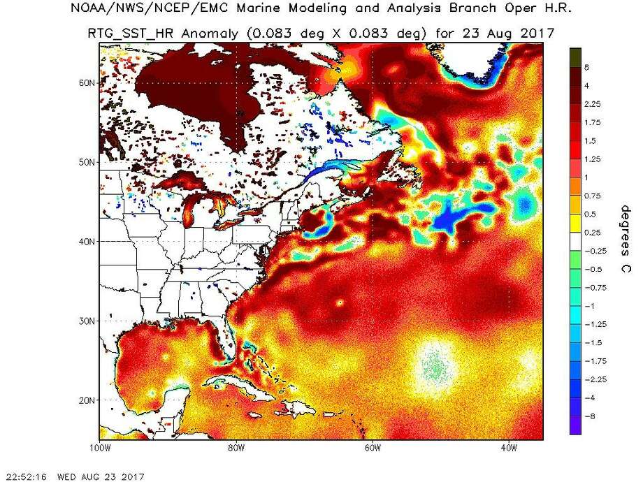
Photo: National Oceanic And Atmospheric Administration
Global warming is making the oceans hotter, fueling the intensity and flooding potential of storms like Harvey, climate scientists said as the hurricane approached.
Driven by higher-than-average temperatures in the Gulf of Mexico, Harvey quickly intensified Thursday and is likely to reach Category 3 hurricane status before it hits the Texas Coast.
Sea surface temperatures in the Gulf on Thursday were up to 2 degrees above normal, the National Oceanic and Atmospheric Administration reported.
The average temperature for most of the Gulf was 86 degrees, said Kevin Trenberth, a climate scientist with the National Center for Atmospheric Research in Boulder, Colorado.
“That makes it almost the hottest spot on the planet” for sea surface temperatures, Trenberth said. “It’s an area that’s ripe for vigorous development to occur.”
Harvey is projected to make landfall late today or early Saturday. As it sits over the inland Gulf Coast, it could bring rainfall of 10 to 20 inches Friday through Tuesday along and east of Interstate 35,the National Weather Service said. More than 25 inches could fall near and south of Interstate 10, and the Hill Country could get 5 to 10 inches.
As the Earth’s climate warms because of human burning of fossil fuels, scientists have seen tropical cyclones become more intense and predict they will continue doing so.
Since the 1980s when high-quality satellite observations became available, scientists have seen an increase in the “intensity, frequency, and duration” of Atlantic hurricanes, along with the number of Category 4 and 5 storms, according to the 2014 National Climate Assessment.