Via: IceAgeNow.info

This is according to the European model, which is very accurate this far out.
#
**WIDESPREAD BLAST OF COLD AIR PLUNGES FROM ALASKA TO THE WESTERN US EARLY NEXT WEEK AND THEN EXPANDS INTO THE EASTERN US**
Overview
While we end November on a warm note here in the eastern US, there are changes unfolding across the Northern Hemisphere that will likely bring a widespread very cold air mass into the US next week. This cold air mass is first going to arrive in Alaska this upcoming weekend with some spots in that state plunging to 40 degrees below zero and way below normal for early December. After that, the cold air dives into the western US during the first half of next week and then it’ll likely blast into the eastern US late next week. In fact, by the time Saturday, December 10th rolls around, there may be colder-than-normal conditions all the way from Alaska to the southeastern US. Beyond that, it looks like this colder pattern will indeed have some staying power as we move deeper into the month of December.
Details
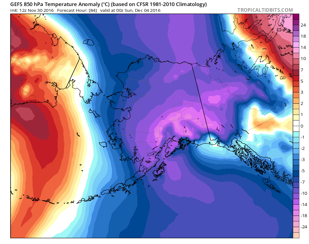
A loop (above) of 12Z GEFS 850 mb (~5000 feet) temperature anomaly forecast maps across North America shows quite well the plunge of the cold air mass next week from Alaska into the western US and then finally its expansion into the eastern US at then end of next week. The 7-day loop of 850 mb temperature anomaly forecast maps progresses from this Saturday, December 3rd to the following Saturday, December 10th with colder-than-normal conditions shown in blue and purple and the warmer-than-normal air in red and orange.
Following the passage of today’s frontal system, temperatures will cool down here on Thursday and then even colder air pushes in for the weekend with possible snow showers early next week. We will then likely warm up considerably once again in the eastern US during the middle and latter part of next week ahead of the cold blast which will initially dive into the western US. A major storm could actually form along the frontal boundary zone by the mid-to-late part of next week which would bring more rain here (at least initially) and perhaps significant accumulating snow to parts of the Upper Midwest. By the end of next week, the Arctic front separating the warm air to the south and east and cold air to the north and west is likely to plow through the Mid-Atlantic region ushering in the cold air mass all the way down into the Southeast US. Longer term, signs point to colder-than-normal conditions sticking around here as we progress through the month of December.
Meteorologist Paul Dorian
Vencore, Inc.
vencoreweather.com