
By Paul Homewood

http://www.woodfortrees.org/plot/rss/plot/rss/from:1998/trend
Pronouncements of its death were premature – the pause has never gone away!
Despite temperatures peaking in February, just above the 1998 peak, satellite measurements show that temperature trends have only risen by a statistically insignificant 0.002C/year since 1998.
Pause deniers always object to comparisons with 1998. However, as we are now comparing two massive El Nino years, that objection no longer carries any weight.
That is not all. The strong La Nina event in 1999/2000 effectively cancelled out the 1998 El Nino, as far as trends go, as the Met Office explained in their 2013 paper, “The recent pause in global warming: What are the potential causes”:
The start of the current pause is difficult to determine precisely. Although 1998 is often quoted as the start of the current pause, this was an exceptionally warm year because of the largest El Niño in the instrumental record. This was followed by a strong La Niña event and a fall in global surface temperature of around 0.2oC (Figure 1), equivalent in magnitude to the average decadal warming trend in recent decades. It is only really since 2000 that the rise in global surface temperatures has paused.
It remains to be seen whether we get a similar La Nina in the next 12 months, but even a return to average temperatures will see the above trend drop close to zero.
One question that is often raised is why temperatures are still close to record levels, even though El Nino conditions have largely disappeared. The answer is that there is always a time lag between ENSO changes, and the resultant impact on atmospheric temperatures, generally agreed to be between three and six months.
Below is a chart showing the timing of ENSO and temperature changes between January 1997 and December 1999:

The MEI (Multivariate ENSO Index) shows how the El Nino peaked in September 1997, whilst RSS temperatures did not peak until the following April.. Similarly, the subsequent La Nina bottomed out in February 1999, with temperatures not following suit until June 1999.
A similar chart for this year shows a five month between lag between the two peaks. It seems likely that the recent transition towards neutral ENSO conditions won’t be reflected in atmospheric temperatures until the autumn. Beyond that, it is crystal ball time!

One more thing to note. The MEI is actually a bimonthly assessment.
What I show as June, for instance, is actually May/June. ESRL, who operate the MEI state in their latest report, on 3rd July:
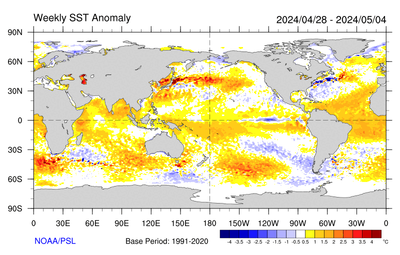
Positive SST anomalies cover much of the off-equatorial tropical Pacific, but cold anomalies are present right along the Equator east of 160W, as seen in the latest weekly SST map. This remains one of the more clear-cut cases where the bimonthly assessment in the MEI sense cannot keep up with the faster changes underway now.
It is therefore highly likely that, although they still show what they call a moderate El Nino, in reality the ENSO conditions in June were almost certainly in neutral territory.
