
http://icecap.us/index.php/go/joes-blog/sea_level_acceleration_that_other_big_lie/
Sea-Level Acceleration – That Other Big Lie
By Joseph D’Aleo, Nils Axil Morner and Tom Wysmuller
NOAA Ocean Service 2022 report:
The Next 30 Years of Sea Level Rise “Sea level along the U.S. coastline is projected to rise, on average, 10 – 12 inches (0.25 – 0.30 meters) in the next 30 years (2020 – 2050), which will be as much as the rise measured over the last 100 years (1920 – 2020). Sea level rise will vary regionally along U.S. coasts because of changes in both land and ocean height.”
REBUTTAL This claim is demonstrably false. It really hinges on this statement: “Tide gauges and satellites agree with the model projections.” The models project a rapid acceleration of sea level rise over the next 30 to 70 years. So it must be true. However, while the models may project acceleration, the tide gauges clearly do not.
All data from tide gauges in areas where land is not rising or sinking show instead a steady linear and unchanging sea level rate of rise near 4 inches/century, with variations due to gravitational factors. It is true that where the land is sinking as it is in the Tidewater area of Virginia and the Mississippi Delta region, sea levels will appear to rise faster but no changes in CO2 emissions would change that. The implication that measured, validated, and verified Tide Gauge data support this conclusion remains simply false.
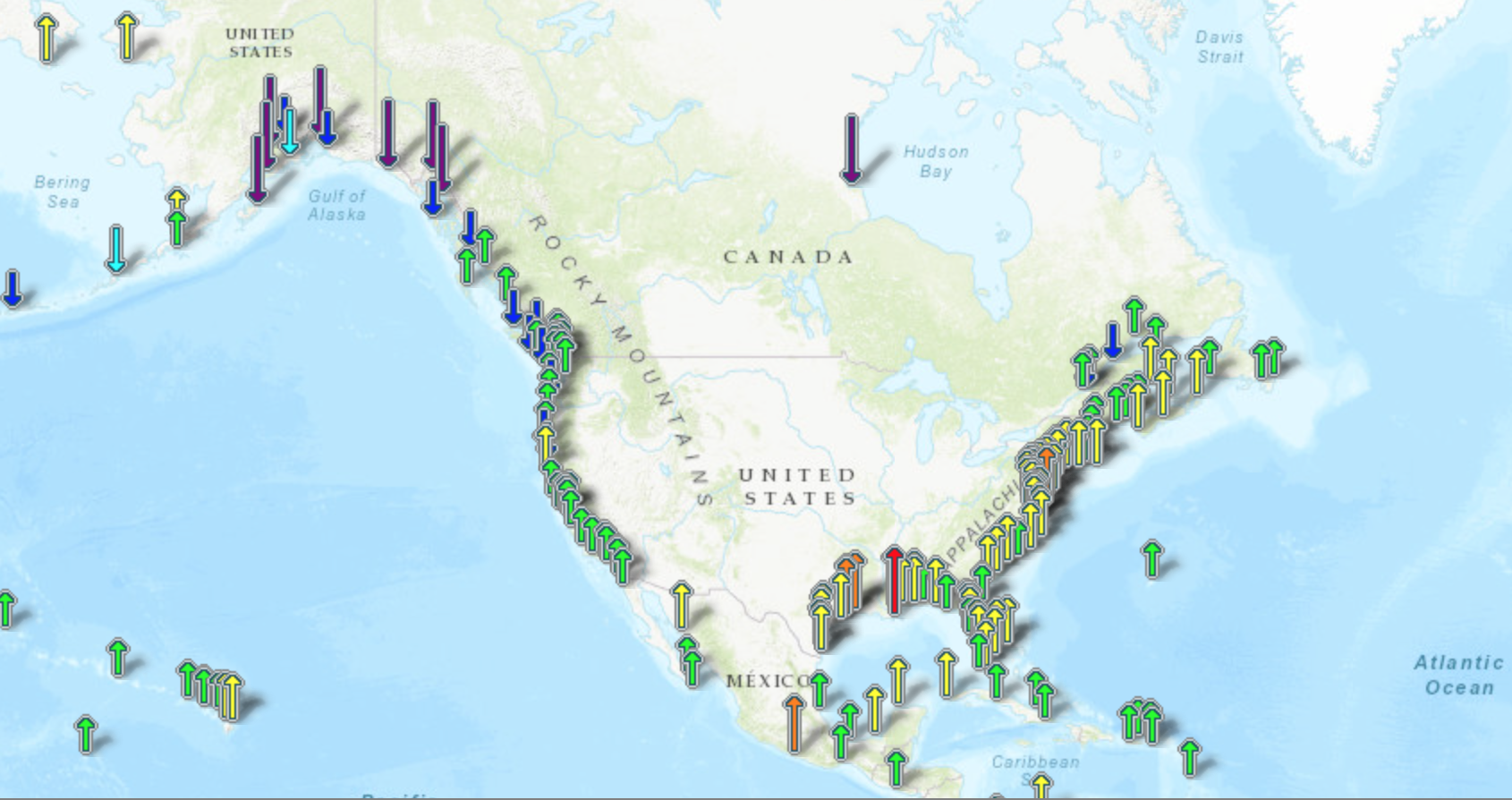
All such references rely on “semi-empirical” information, which merges, concatenates, combines, and joins, actual tide gauge data with various models of the reference author’s choosing. Nowhere on this planet can a tide gauge be found, that shows even half of the claimed 3.3 mm/yr sea level rise rate in “Tectonically Inert” coastal zones. These are areas that lie between regions of geological uplift and subsidence. They are essentially neutral with respect to vertical land motion, and tide gauges located therein show between 1 mm/yr (3.9 inches/century) and 1.5 mm/yr (6 inches/century rise).
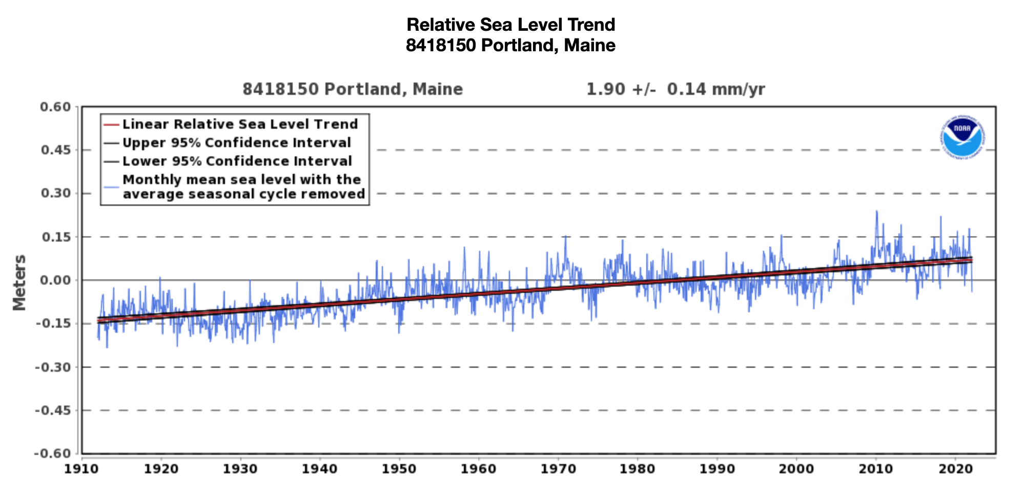
At the northern end of the sinking land areas in Portland, Maine, a change of just 1.9mm/year (7.5 inches a century).

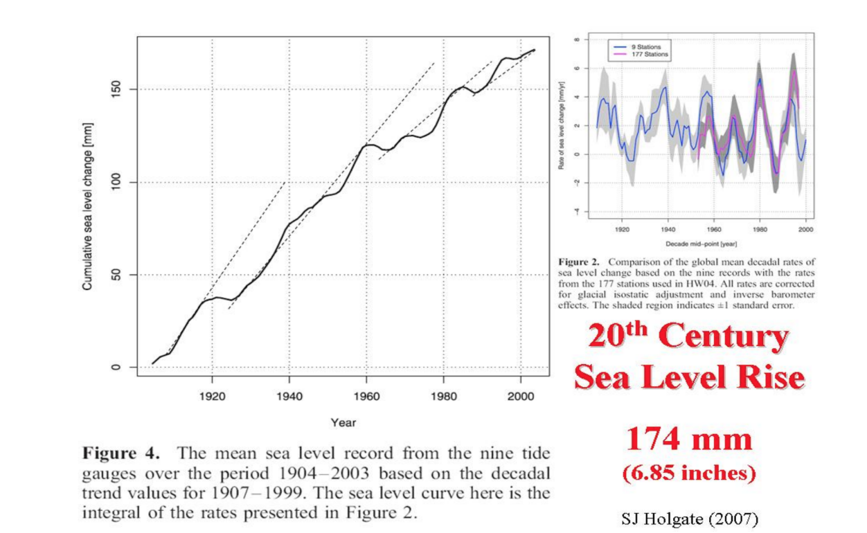
Holgate (2007) showed the slowing as the glacial melt slowed and the current trend slope pales in comparison to the long-term trend.
Source here.
A Real Expert on Sea levels
The great Swedish Oceanographer, Nils-Axel Morner, has commented on this extensively, and his latest papers confirm this ‘inconvenient truth’. Furthermore, alarmist claims that “Satellites agree with the model projection” are false.
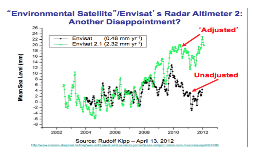
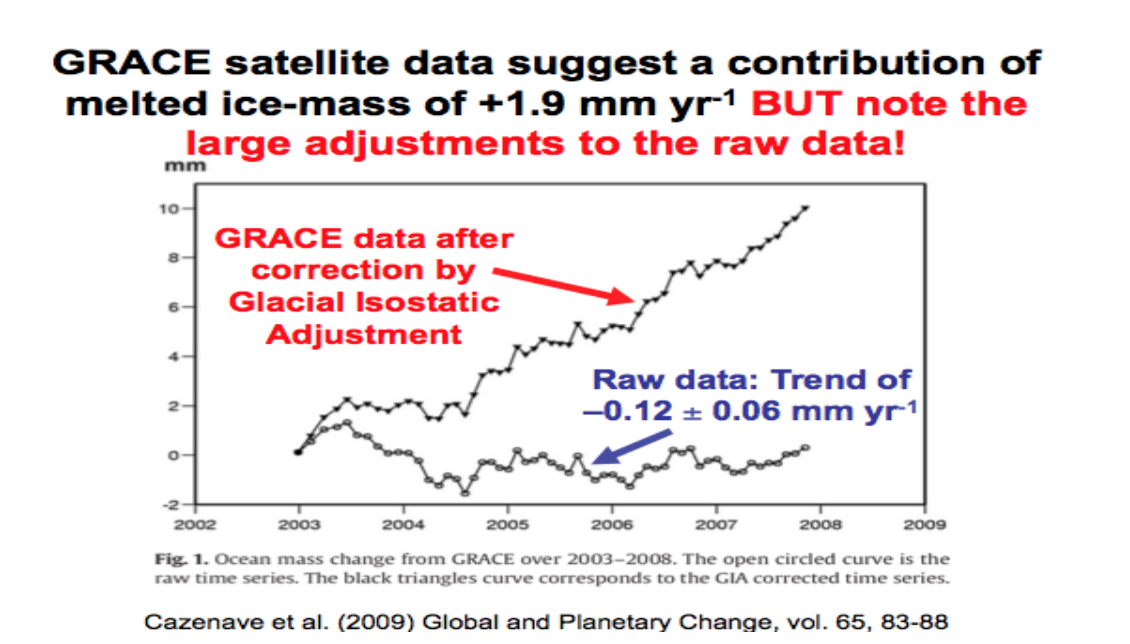
Because of local factors affecting gauges, technology was introduced to provide more objective measurement of sea level rise. In all cases the new satellite and radar altimeter data showed flat or even decreasing sea levels. Since these results conflicted with previous alarmist model forecasts and claims, adjustments to this data were made – including a Glacial Isostatic Adjustment GIA). GIA assumes that land is rebounding from long ago glaciations and oceanic basins are deepening and thus is masking the true sea level rise.

The assumption is that this rebounding is masking the true sea level rise. Alarmists continue to proclaim that their models project a rapid acceleration of sea level rise over the next 30 to 70 years, when those same models have failed to even come close to accurately predicting the past 25 years. So like with other inconvenient data, they push the agencies to “fix it” to fit the models instead of rethinking the models.
A new study affirms what satellite data have been telling us for years: ‘the global coastline is prograding.’ This isn’t the first time shoreline expansion in the era of global warming and allegedly rapid sea level rise has been documented. A 2019 global-scale analysis of 709 islands in the Pacific and Indian Oceans revealed 89% were either stable or growing in size, and that no island larger than 10 ha (and only 1.2% of islands larger than 5 ha) had decreased in size since the 1980s. Likewise, the globe’s beaches have been growing by 0.33 m/year since 1984.
In a press release for a 2016 paper on coastal land area changes from 1985 to 2015, scientists acknowledged this: ‘We expected that the coast would start to retreat due to sea level rise, but the most surprising thing is that the coasts are growing all over the world’ – BBC. Today there are high resolution satellite images available from Google Earth clearly demarcating global-scale decadal shoreline change since the 1980s. Claims of dangerously accelerating sea level rise posing an imminent global threat to coasts have once again been challenged by real-world observational evidence.” Indeed, global warming is not resulting in rising sea levels.
——–
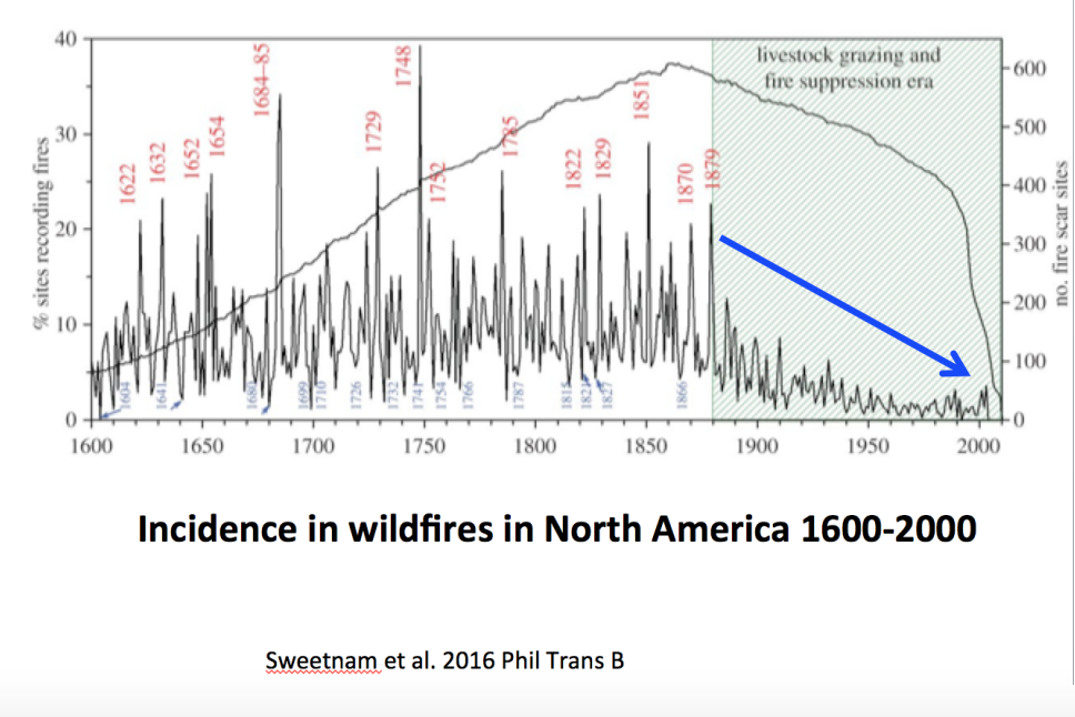
The Biden OMB in the same releases on sea level threats talked about the increased dangers with wildfire and hurricanes. We have shown here that any increase in the impacts of annual dry season forest fires are a forest management and environmental and governmental policy induced issue, not a Global Warming induced one. They had declined the last century until environmentalists who have a distain for foresters, farmers and ranchers took over control.

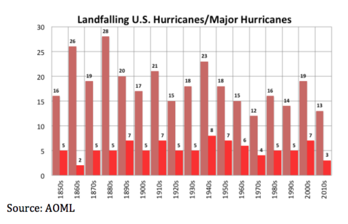
Hurricane damages have increased as the property at risk in the attractive coastal areas skyrocketed. Losses for 2018 were estimated at $91 billion and for 2019 were $45 billion. This past decade was the quietest one for landfalling hurricanes (behind the 1970s) and major hurricanes (behind only the 1860s).

See more here
