
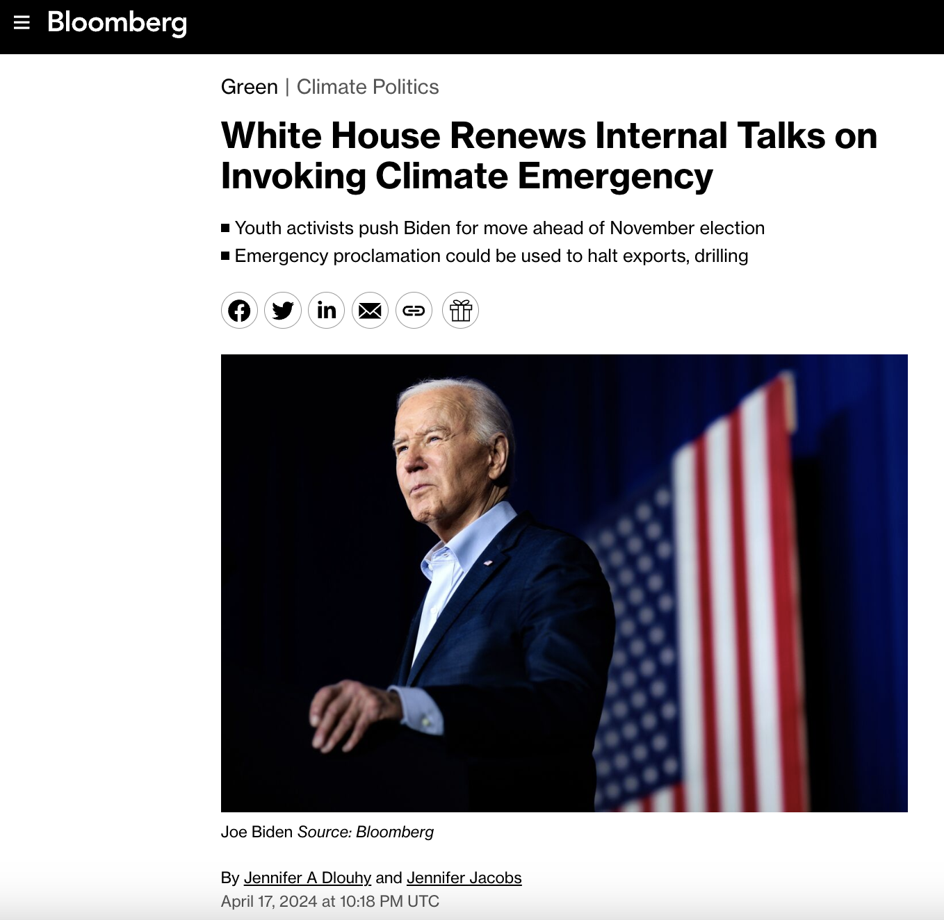
https://www.cbsnews.com/news/climate-change-disinformation-suing-fossil-fuel-companies/
If climate change were a disaster film, it would likely be accused of being too over-the-top: wildfires reducing entire towns to ashes, hurricanes swamping cities, droughts draining lakes and withering fields, and raging oceans redrawing the very maps of our coasts. And now, many cities and states are asking, who’s going to pay for all of this?
“This is real; we’re on the front line of climate change right here in Charleston,” said John Tecklenburg, the mayor of Charleston, South Carolina. The city’s been battered by an endless parade of floods due to sea level rise. Some desperate homeowners have resorted to raising their homes by several feet.
“In the next 50 years we’ll see another two to three feet of sea level rise,” Tecklenburg said. “The water is our greatest asset; it has also become our biggest challenge.”
So, the city is raising large parts of its existing sea wall, and the Army Corps of Engineers says Charleston should build another eight miles of wall. The city expects an estimated $3 billion in climate change-related costs.
Correspondent Ben Tracy asked, “Can you raise taxes high enough to cover these costs?”
“It’s like any big project; you gotta look under every rock,” Tecklenburg replied.
Underneath one of those rocks are the fossil fuel companies. Study after study has shown the companies’ carbon emissions from oil, coal and gas are major contributors to climate change.
Charleston is one of more than two dozen cities, counties and states that are suing these companies (including ExxonMobil, Shell, Chevron, BP and ConocoPhillips).
Tecklenburg said, “I feel if you’ve contributed to the problem, that you should contribute to the solution.”
“So, in some ways, it is a bit of a money grab?” asked Tracy.
“Well, to the extent that they participated in what created this need; it’s a money grab because there’s some responsibility for what happened.”
The suits are modeled after the “Big Tobacco” cases of the 1990s, and accuse the companies and industry groups of making false and misleading claims about climate change.
If climate change were a disaster film, it would likely be accused of being too over-the-top: wildfires reducing entire towns to ashes, hurricanes swamping cities, droughts draining lakes and withering fields, and raging oceans redrawing the very maps of our coasts. And now, many cities and states are asking, who’s going to pay for all of this?
“This is real; we’re on the front line of climate change right here in Charleston,” said John Tecklenburg, the mayor of Charleston, South Carolina. The city’s been battered by an endless parade of floods due to sea level rise. Some desperate homeowners have resorted to raising their homes by several feet.
“In the next 50 years we’ll see another two to three feet of sea level rise,” Tecklenburg said. “The water is our greatest asset; it has also become our biggest challenge.”
#
Rebuttal: Charleston SC’s Junk Climate Change Lawsuit- Geologist David Middleton – WattsUpWithThat.com
“In the next 50 years we’ll see another two to three feet of sea level rise,” Tecklenburg said. “The water is our greatest asset; it has also become our biggest challenge.”
[…]
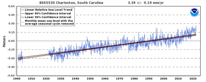
interval of +/- 0.19 mm/yr based on monthly mean sea level data from
1901 to 2021 which is equivalent to a change of 1.11 feet in 100 years.
NOAA
- 3.39 mm/yr * 50 yr = 169.5 mm
- 169.5 mm / 25.4 mm/inch = 6.67 inches ~ 0.5 feet
“What about sea level rise acceleration?”
What about it?
Variation of 50-Year Relative Sea Level Trends
8665530 Charleston, South Carolina
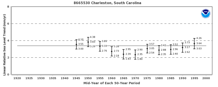
Linear relative sea level trends were calculated in overlapping 50-year increments for stations with sufficient historical data. The variation of each 50-year trend, with 95% confidence interval, is plotted against the mid-year of each 50-year period. The solid horizontal line represents the linear relative sea level trend using the entire period of record.
Although the trend may vary with the end year, there is no statistically significant difference between the calculated trends if their 95% confidence intervals overlap. Therefore, the most recent calculated trend is not necessarily more accurate than the previous trends; it is merely a little more precise. If several recent years have anomalously high or low water levels, the values may actually move slightly away from the true long-term linear trend.
“But, but, I see a trend there!”
Even though “there is no statistically significant difference between the calculated trends if their 95% confidence intervals overlap,” let’s just assume that apparent trend is real.

This would lead to a rate of sea level rise of 4.78 mm/yr in 2071. Just to make the math easier, if sea level rose at a rate of 4.78 mm/yr over the next 50 years, it would result in 9.4 inches of additional sea level rise… ~ 0.75 feet.
So, where in the hell is the money-grubbing Democrat mayor of Charleston getting two to three feet of additional sea level rise over the next 50 years? Possibly from the same folks, whose data indicate 0.5 to 0.75 feet of sea level rise over the next 50 years.
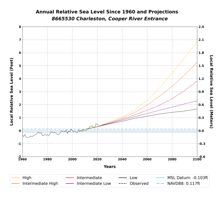
The figure shows the station’s annual mean relative sea level with its six regionalized sea level rise scenarios plotted relative to a 1991-2009 baseline period (i.e., year 2000 is the ‘zero’ for the figure) as described in the report on Global and Regional Sea Level Rise Scenarios for the United States.
The “high” scenario has sea level rising by 750 mm (0.75 m) from 2080 to 2100, an average rate of 36 mm/yr. This is physically impossible. The average rate of sea level rise during the Holocene Transgression was only about 11 mm/yr.
The “intermediate” scenario features 400 mm of sea level rise from 2080 to 2100, an average rate of nearly 20 mm/yr over that 21 year period. Again, short of Doctor Evil melting the Greenland Ice Sheet with a space “laser,” this is physically impossible.
As is often the case in alarmist climate models, the “low” scenario represents the maximum sea level rise supported by actual observations.


Context: Tidal Ranges
Sea level rises (and falls) by 6 feet over a typical Charleston day…

Context: Subsidence
Scientists Working to Understand Sinking Land in Charleston, South Carolina
By Jan Wesner Childs September 23, 2020[…]
Data from a NOAA gauge in Charleston shows that about 5 of the 12 inches of sea-level rise at the site over the past 100 years can be attributed to subsidence. It’s not clear why the land is sinking.
One theory: it has to do with soil compression caused by large buildings, highways and other increased development.
“We’ve had buildings on the peninsula. Now we’re getting much bigger buildings on the peninsula,” Norm Levine, director of the Lowcountry Hazards Center at the College of Charleston, told the Post and Courier. “If we get out there now and kind of measure things, we can start understanding the susceptibility.”
[…]
The total sea level rise at Charleston over the past 100 years is just over 1 foot.
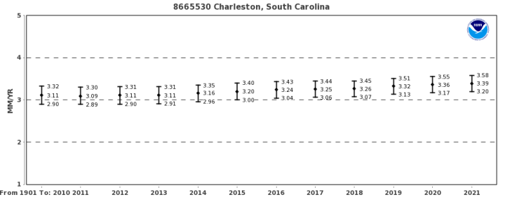
The relative sea level trend is 3.39 millimeters/year with a 95% confidence interval of +/- 0.19 mm/yr based on monthly mean sea level data from1901 to 2021 which is equivalent to a change of 1.11 feet in 100 years.

If 5 to 12 inches Charleston’s sea level rise is due to subsidence and there has only 13 inches of sea level rise, the money-grubbing Democrat mayor has a zoning problem, not a climate change problem. I wonder if Charleston advised purchasers of their bonds about this local problem?
I previously wrote about this junk lawsuit in this September 2020 post:
Charleston SC Junk Climate Lawsuit
Some highlights from that post:
South Carolina Flood Frequency Q&A
In 2015, Dr. Robert Holmes, USGS National Flood Hazard Coordinator, took time to discuss some issues related to the flooding in South Carolina following the Appalachian Floods and Hurricane Joaquin.
[…]
Is this flood due to climate change?
USGS research has shown no linkage between flooding (either increases or decreases) and the increase in greenhouse gases. Essentially, from USGS long-term streamgage data for sites across the country with no regulation or other changes to the watershed that could influence the streamflow, the data shows no systematic increases in flooding through time.
A much bigger impact on flooding, though, is land use change. Without proper mitigation, urbanization of watersheds increases flooding. Moreover, encroachment into the floodplain by homes and businesses leads to greater economic losses and potential loss of life, with more encroachment leading to greater losses.
JUNE 24, 2014
The History Behind Flooding in Charleston, South CarolinaFor many the idea of sea level rise and its associated impacts are thought of as future events. But, here in Charleston it’s already a part of life. Coastal flooding is a major issue that the city faces. All it takes is just the right tide, or even worse, an extreme high tide paired with a torrential downpour during rush hour, and Charleston’s streets become fingers of the Atlantic Ocean that no car can ford. It’s not hard to fathom that these flooded streets will one day become creeks and marshes. And in many cases that is what they once were.
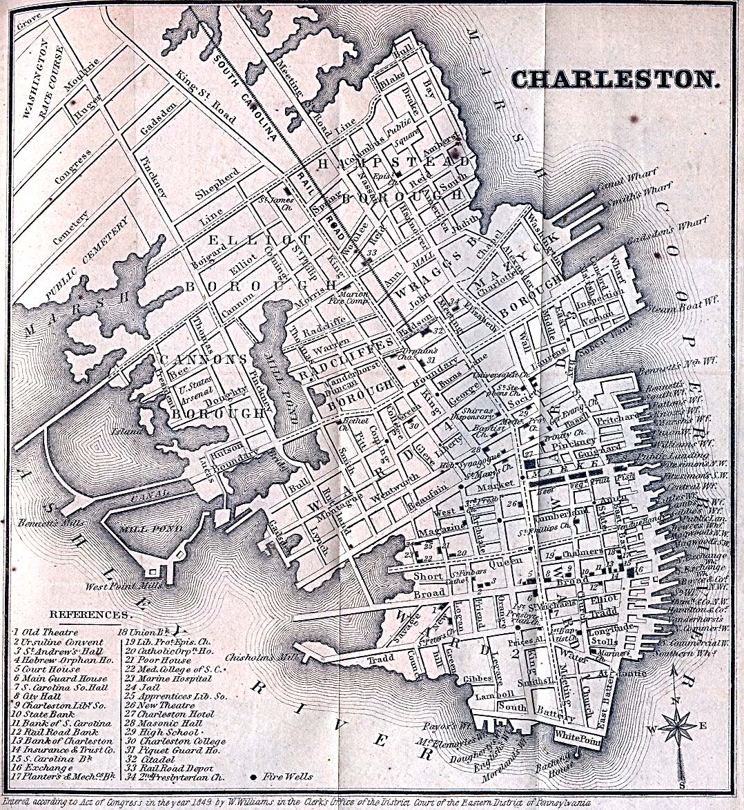
As far back as the 18th century, Charlestonians have made a practice of expanding the city’s footprint by filling creeks and marshes. Alfred O. Halsey’s Historic Charleston on a Map provides an amazing illustration of the change to the peninsula’s landscape (Preservation Society of Charleston [PSOC]). The map shows that many areas that frequently flood are atop man made land.
The aptly named Water Street in the South of Broad neighborhood was originally Vanderhorst Creek, until it was filled in 1792. Many are familiar with the images of kayakers paddling through the City Market after wayward bands from Hurricane Isaac flooded the city. This could have been a common sight if what was once Governor’s Creek wasn’t filled in to create Market Street in first decade of the 19th century. Both the Charleston Village and Cannonborough neighborhoods were filled in during the mid 1800s and both are notorious for their flood problems. The city has continued to alter the coastline as late as the 1960s. During this time, Lockwood Boulevard was constructed which resulted in cutting off the Charleston Municipal Yacht Basin from the Ashley River and converted it into a placid pond (Thompson 2013).
[…]
Geozone (NOAA Office for Coastal Management)
I put together a comparison of Halsey’s 1949 historical map (Preservation Society of Charleston) and an 1869 Charleston street map (University of Texas):

Charleston floods because they built much of the city in the Atlantic Ocean. And… let’s not forget subsidence.
#
Mike Shellenberger, the President Breakthrough Institute, and a man who Time Magazine called ‘Hero of the Environment’: ‘The picture painted of Exxon seeking out & funding “climate change deniers” to mislead public & prevent climate policy is false.’
‘The picture painted by @insideclimate is that Exxon was paying people to lie about climate while acknowledging it privately…In reality, Exxon funded conservative think tanks that were mostly *not* “climate deniers” — & in many cases advocate climate policy!’
But it was always obvious from looking at who Exxon funded that vanishingly few people were “climate change deniers.” A vast Exxon conspiracy to deceive public about climate turns out to be… a lukewarmish NYT ad & sunspots research.’
